Post Views: 406
H. Data analysis training with Q-GIS Software
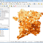
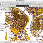
Definition of Q-GIS Software:
QGIS (previously known as “Quantum GIS”) is an open-source geographic information system (GIS) application that facilitates viewing, editing, and analysis of geospatial data.
When discussing data analysis services in QGIS, it generally revolves around:
- Data Visualization: QGIS allows for the visualization of spatial data. Users can overlay multiple layers to create composite maps, categorize data into different symbologies, and utilize a range of colors, sizes, and symbols to represent different data values.
- Spatial Analysis: This involves analyzing the spatial relationships between layers. For example, QGIS can determine which points fall within a given polygon, calculate the distance between features, or derive new shapes based on intersections, unions, or differences between layers.
- Raster Analysis: QGIS isn’t limited to just vector data; it can also process raster data (like satellite imagery). Users can perform tasks like hillshade analysis, slope calculations, or extract value from raster based on vector locations.
- Geoprocessing Tools: These are tools that allow you to manipulate data. For instance, you can buffer around features, merge or split layers, or intersect multiple layers.
- Geocoding and Georeferencing: Turning addresses into spatial data (points on a map) is known as geocoding. Meanwhile, georeferencing involves taking a non-spatial image (like a scanned map) and providing it with spatial reference points, thus integrating it into the GIS environment.
- Database Integration: QGIS can connect to spatial databases, allowing for more sophisticated data queries and management.
- Customization and Scripting: Advanced users can utilize Python and the PyQGIS library to automate tasks or create custom plugins for specialized analyses.
Research Expert Solutions provides data analysis training services in Q-GIS by:
- Requirement Gathering: Understand the client’s specific GIS needs and objectives.
- Data Collection: Acquire necessary spatial data, which might include purchasing datasets, using open-source datasets, or even field data collection.
- Data Processing and Cleaning: Ensuring the data is ready for analysis, which might involve removing errors, filling in missing data, or converting data formats.
- Analysis: Employing the range of tools in QGIS (or other GIS platforms) to derive insights, patterns, or specific outputs based on the client’s requirements.
- Presentation and Visualization: Creating maps, charts, or other visual aids to present the analysis findings.
- Recommendation and Strategy: Based on the analysis, providing actionable insights or strategies for the client.
- Training and Support: If the client wishes to maintain or further work with the GIS environment, the company may offer training sessions or ongoing support.